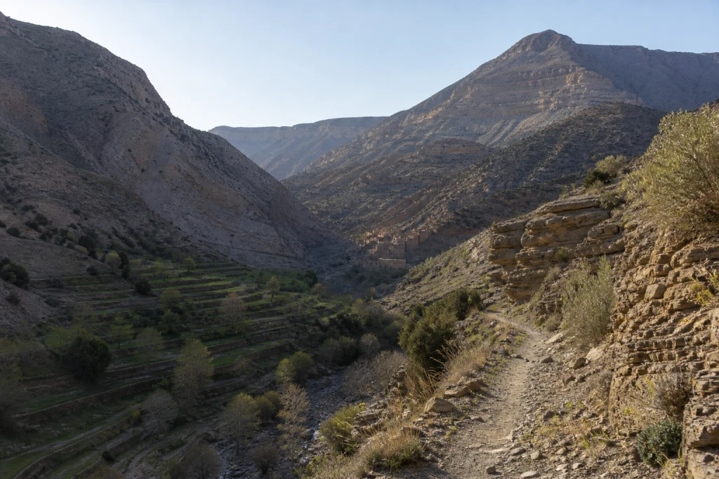
M’Goun appears on UNESCO’s official list of Global Geoparks. The organisation’s profile places it in the central High Atlas and records a 2015 designation. This status does not turn the whole region into a theme park or one continuously marked route. It recognises a territory where geological heritage, biodiversity, cultures and local development are meant to be understood together.
For a traveller, the useful information is not simply the word “UNESCO”. You need to understand the scale, select a valley or geosite that fits the available time, then check the road, weather, guiding and local rules. MOP presents the label as a framework for reading the landscape, never as a promise of permanent access.
A geopark is not a single monument
UNESCO describes a geopark as a coherent territory that manages geological heritage of international significance with its natural and cultural dimensions. M’Goun includes several valleys, landforms, villages and sites. It therefore has no single entrance after which everything becomes immediately accessible.
That difference changes planning. A waterfall, agricultural valley, fossil tracks or a rock formation may be separated by substantial distances. A dramatic photograph gives neither road conditions nor journey time. Build the programme around a real base and a limited number of stops.
More than two hundred million years to read
The UNESCO profile connects the territory with more than two hundred million years of Earth history and the formation of the central High Atlas. It refers to dinosaur footprints, Jurassic rocks and several mineral resources. These markers make the landscape meaningful, but they require serious interpretation.
A footprint or geological layer must not be touched, moved or treated as a souvenir. Observe, photograph without damage and use a guide or interpretation centre when the site requires one. Scientific precision is more valuable than an improvised legend.
The territory is lived in and worked
UNESCO also stresses communities, terraced crops, irrigation systems, granaries, kasbahs and skills. This is not an empty landscape: it reflects farming, movement, rights of use and long adaptation to the mountain environment.
Travellers should distinguish a public path from a route through a plot, ask before photographing a person or interior and avoid blocking a working track. Buying a local product does not by itself make a visit responsible; behaviour on the ground matters as much as spending.
Azilal is a starting point, not a shortcut
The UNESCO profile identifies Azilal as one of the territorial references. The town can serve as an information or organisation base, but it does not make nearby geosites instantly close. High Atlas valleys often involve winding roads, uncertain travel times and conditions that change by season.
MOP’s guide to Azilal and Ouzoud helps structure a stop without confusing the town, the waterfalls and the entire geopark. Confirm the exact departure point before booking an activity or accommodation.
What the designation does not guarantee
The label guarantees neither daily opening, a passable road, an available guide nor universal accessibility. It also does not mean that every offer using the M’Goun name is approved by UNESCO. Commercial services remain the responsibility of their operators.
Before paying, request the exact place, time on site, vehicle, group size, language, equipment and cancellation terms. A credible offer makes road time and limitations visible. It does not rename a long day in transport as “immersion” without detail.
Treat mountain conditions as a variable
Altitude, wind, rain, heat, snow and track conditions can alter a programme. Consult the official weather-vigilance service and confirm conditions locally. A climate average does not replace the day’s forecast, and a road open in the morning may require a different return decision.
Carry water, sun protection, a warm layer, suitable footwear and a daylight margin. If an activity depends on a crossing, isolated hike or track, require a clear fallback procedure. Dropping an uncertain stop protects the trip rather than diminishing it.
Read the label without overpromising
M’Goun’s place on the UNESCO list is an important reference for Morocco. It makes visible a territory where geology and local life cannot be separated. It also creates a responsibility: the label must not become a decorative marketing shortcut.
MOP will keep editorial context separate from any booking. An article can explain the territory without displaying an offer. An activity should appear only when its anchor, operator and relevance are verified, while price and availability remain with the provider.
Before you leave
- Choose one valley or geosite, not “the whole geopark” in one day.
- Check road, weather, guide, equipment and return through recent sources.
- Respect fields, villages, fossils, rocks and local instructions.
- Never confuse UNESCO status with approval of a commercial offer.
- Keep a simple alternative when mountain conditions require change.